~ How to Find and Use Topographical Maps for Lake Keowee Homes and Land ~
We understand that your time is valuable.
One of our goals is to not only have you enjoy your trip here, but to make your time with us quality time.
“Let your fingers do the walking!”

Use our VIP Property Search form to get Immediate Updates of properties for sale!
Have you ever wanted to find out how steep a lot is before you go and see it in person? That information is available on County web sites. Often, a low price for a lot looks like a steal. Beware that this is usually done to compensate for the expensive foundation you will need because of steepness or a gully! Remember, this is a mountain lake with communities built on the tops and slopes of mountains and hills.
Most counties now have a GIS (Geographic Information System) that allows you to see the topography of a lot, revealing steep cliffs or gullies that you can't see from the listing photos. They show this by drawing red lines on the map that represent elevations. The distance between two of these lines marks a change in elevation, usually of 4 feet or 8 feet.
Oconee and Pickens are the counties on Lake Keowee. These instructions are for those counties; they use the same system. The county name will be in each listing so you know which one to use. Other counties have either the same system or similar ones.
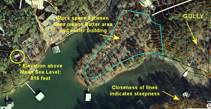
The photo above shows how the lines indicate gullies, steep areas and flat areas for good building locations. * To the left, you'll see the number 816 which is the elevation in feet above Mean Sea Level. Note that this line shows the shape of the land at that elevation along its entire length.
The blue line is the approximate boundary of the lot. These are tax maps, not surveys! There is no guarantee that the property lines shown for any parcel will exactly match an actual survey but it will be close. Never count on tax maps for a completely accurate lot size or shape. The reason you don't see lot lines going to the water's edge is that Duke Energy owns the land outside those lines toward the lake up to an elevation of 804 feet above Mean Sea Level. Our Lake Gallery page has a PDF from Duke Energy that explains this further along with their shoreline management guidelines. There is also a brochure for the Oconee County Vegetative Buffer requirements.
We have several excellent Keowee Custom Builders in our area. They have built homes for many of our clients so we feel confident in recommending them. We work very closely with them to help determine which land is right for you and your new home. Together, we will walk your potential land and will examine the topography which will determine the location of home site, placement of the driveway and septic. It is important to us that you have a, “fine building experience.” Our informative Keowee Custom Builder page has links to custom house plans from prominent designers such as Donald Gardner and Southern Living.
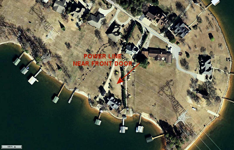
We are agents who tell you the good, bad and ugly. Power lines in your view or very close to the house can be a major issue for resale. Several years ago, we sold a million dollar waterfront home to a Duke Energy engineer that had mega power lines and a tower in his yard. His wife is an avid photographer. Since the power lines were so high, it enabled them to look under the power lines and not have them in the view. This gave her the opportunity to get beautiful sunset photos over the lake with the Blue Ridge Mountains in the background. Obviously, they are not concerned about radiation coming from the lines because it is so minor. There are many Duke Energy retirees who own waterfront homes on Keowee. It gives us great comfort to know that they are living here by choice with a nuclear power plant nearby with no fear of a problem in the future.

The photo above shows a problem with power lines. This home was a very hard sale. These lines did not obstruct their lake view because the home was on the lake side of the power lines. However, from the front door, you could hear the hum and crackling of the power lines. We know your time is valuable, as is ours. We do not want you to come and look at a property without having full knowledge of any potential issues. Therefore, before you view a home, we always look at the County map which will reveal if there are power lines in the view or if there are other nearby issues that could affect its value. If there are, we will reveal it to you. You can also do this research in advance as well. NOTE! We reluctantly helped a buyer buy ths home. We revealed all the issues that could potentially be a problem for resale. We also reluctantly listed the home for them when they decided to sell knowing it would take a long time to find a buyer who would not have a problem with this situation.
Please keep in mind that we are more than happy do this for you. Many people, though, enjoy learning and doing this as part of their due diligence. Many folks come to us these days with a great amount of knowledge before they even get here. Also, our Lake Communities page links to extensive pages on the more upscale communities in the area. On these pages, we have community maps that allow you to see where a property is located within the community. Also there are slideshows of homes and amenities. Some have videos we have made from within the communities and from the lake shore. For your convenience, there is an interactive map on each page for directions. You can also download Covenants and Restrictions; these will include the lot line setbacks. Some communities have setbacks that are larger than the County requires and these will be in the Covenants.
- Download the PDF version of this page if you would like to have a printed copy at hand.
- Go to the Oconee County or Pickens County Property Records Search page.
- There are several options for how to search. Use the Street Address for homes and many lots. Some lots and large tracts of land, though, do not have street addresses. For those, please write or call us and we will send you the Tax ID number; you can search with that or we can do it for you.
- We will use the lot in the top photo as an example. After typing in the parcel number or address and pressing the Search button (unless it goes there first without clicking the button), you will see the Parcel Information page. (If you type in the owners' name, you will see a list of properties they own; select the desired one from the list. Some may not have street addresses. If they do, you will see the corresponding address to the right of the Parcel ID number.)
- Click on the Parcel ID for the property you want to see. This will display a property information page.

- In the blue menu at the top, click Map. This will show the the property outlined in blue (as you see at the top of this page) and in the center of the page. On the Pickens County site, the initial view may be zoomed back so much that the lot is hard to find; look for the lot outlined in blue. On both county sites, it will show the aerial photography of the land by default. TIP: On Pickens, make it easier to see what you're doing by going to the menu on the left of the page and unchecking the Yearly Sales box. This will remove all the color highlighting of lots that have sold recently.
- Zoom in our out, as needed, using either your mouse wheel or the + or - buttons at the top-left of the map display. Zoom out to get an overall picture of where the lot is located on the lake or where it is within the County. You will also see street names.
- Display the elevation contour lines. The distance between these lines is either 4 or 8 feet, depending on the County chosen. Use the left-side menu as follows:
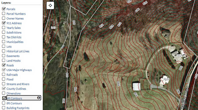
- Pickens. Click 4ft Contours or 8ft Coutours, as desired.

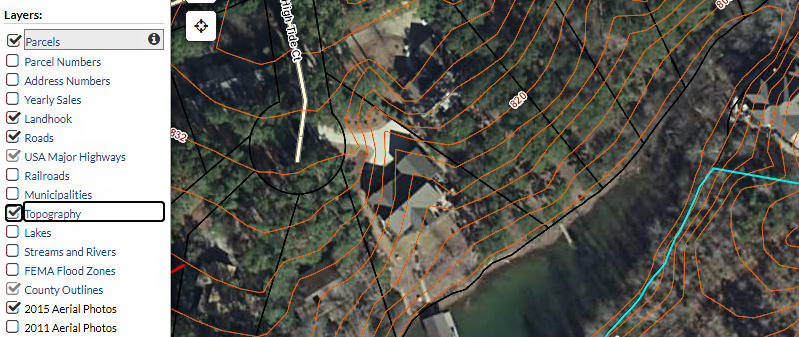
- Oconee. Click Topography. This produces 4ft contour lines. No other options are available.

- Pickens. Click 4ft Contours or 8ft Coutours, as desired.
- You can remove the aerial photography to make the topo lines clearer, if needed, by unchecking the Aerial Photos option.
- The distance legend is at the bottom-left of the map. This will allow you to judge the steepness of the property. I often take a clear ruler to measure the length of the scale at the bottom-left and then move it to the lot and see how many lines fit in that measurement.
If you have any difficulty getting the information needed to the topo map feature, or if the tax number in the MLS is incorrect, please let us know. We will walk you through it over the phone. We are also happy to do this for lots in which you have special interest.